Discover our drone-based 3D scans and models that bring precision and clarity to your projects. We deliver high-quality visual data with minimal impact.
Our workflow combines drone and LiDAR technology to transform landscapes into living digital environments.
Our Process
FROM REALITY TO 3D MODEL
Data Capture
High-resolution aerial photography and videos
Processing
Cloud base processing with Ai-enhanced reconstruction
3D modelling
Interactive 3D modelling and detailed analysis report
Concepting
Develop the 3D model, add design variations and set the forecast you prefer
Omega Studio offers advanced scanning solutions, leveraging the highest quality equipment for environment 3D scanning. Our expertise extends to utilising state-of-the-art technology, both on the ground and in the air. Our suite of tools, delivers unparalleled precision and quality in environmental scanning, digital mapping, and visual effects, providing comprehensive data for a range of projects.
Our Capabilities
Complete end-to-end 3D scanning and visualization services
Photorealistic 3D models
Interactive VR Experiences
Technical Drawings
Point Cloud Analysis
Mesh Optimization
Texture Enhancement
Location scan for Film and Tv
We provide drone-based 3D surveys and LiDAR scanning to capture every detail of a film location with precision. Our workflow transforms raw aerial and ground data into accurate, high-resolution 3D models that directors, producers, and designers can explore as if they were on site. These models are more than simple visual references—they allow teams to test camera angles, experiment with set design, and plan lighting setups before production begins. By replacing static photographs with immersive, interactive replicas, production crews gain a clearer vision of the location, saving time and reducing uncertainties during filming. This digital approach also ensures that sets are thoroughly documented and preserved as permanent records, whether for continuity, future projects, or creative archiving.
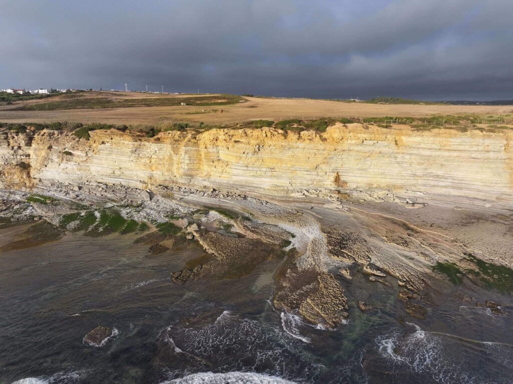
We use drone-based 3D surveys to capture natural environments with exceptional accuracy, generating detailed, high-resolution models of coastlines, landscapes, heritage sites, and protected areas. These 3D digital replicas provide powerful tools for exploration and documentation, allowing researchers, tourism boards, and environmental organizations to study ecosystems remotely without constant site visits.
From monitoring coastal erosion and wave dynamics to preserving cultural landmarks for future generations, our technology supports a wide range of applications. These immersive models can be used to showcase destinations, educate visitors, and guide conservation strategies—combining accessibility, education, and long-term protection in a single digital platform.
We deliver drone-based 3D surveys that give architects and construction teams an accurate digital foundation to plan with confidence. Our scans capture land, terrain, and structures in precise detail, generating high-resolution 3D models that integrate directly into design workflows. This digital approach not only reduces the need for repeated site visits but also saves time and minimizes costly errors during planning and construction.
When working on complex sites with ruins, existing buildings, or irregular landscapes, the value becomes even greater. Instead of manually surveying and recreating data from scratch, our ready-to-use 3D models provide a reliable starting point for concept and design. Teams can focus immediately on developing ideas, testing design options, and refining solutions—streamlining the process and accelerating project delivery.
Our creative process trasforms technical 3d data into compelling visual narratives.
Raw Scan Data
Model Processing
Creative Enhancement
Final Delivery
What You'll Receive
Professional-grade deliverables in multiple formats
High-res Renders
4K+ photorealistic images
3D Models
Optimized for games/VR/AR
Concept Art
Stylized artistic interpretations
Interactive Tours
Web-based 3D experiences
WHAT WE DO
We capture location data with precision and transform it into accurate, high-resolution 3D models.
Using advanced 3D software, we enhance these models with lighting, visual effects, and design variations—testing different construction scenarios, removing unnecessary structures, and shaping the environment to reflect the intended vision. The result is a digital model that goes far beyond a quick site photo with notes: a high-quality, immersive tool for design, decision-making, and client meetings—delivering a far more professional presentation.